PSLV –C 43
IN NEWS
The Indian Space Research Organisation (ISRO) has launched the PSLV-C43 with a payload of 31 satellites. This launch took place from the first launch pad of the Satish Dhawan Space Centre in Sriharikota. Marking the 45th mission that uses the polar satellite launch vehicle (PSLV) rocket, ISRO has launched its latest Earth-mapping satellite, HysIS, as part of the mission.
The co-passengers of HysIS include one Micro and 29 Nano satellites from eight different countries, the agency said, adding, all these satellites will be placed in a 504 km orbit by PSLV-C43.The countries comprise United States of America (23 satellites), Australia, Canada, Columbia, Finland, Malaysia, Netherlands and Spain (one satellite each).
PSLV-C43
The PSLV launcher has a total length of 39.4m and consists of a four-stage rocket, that has alternating solid and liquid stages. PSLV-C43 is a core-alone version of the launch vehicle, and the lightest one in operation.
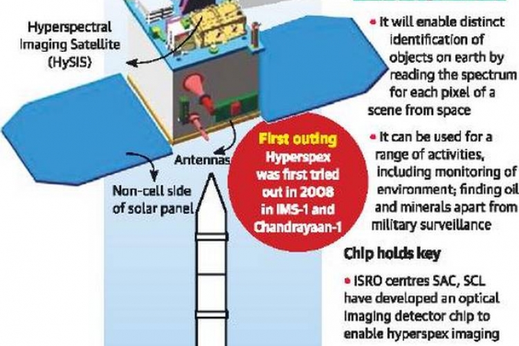
HysIS:
HysIS is an earth observation satellite developed by ISRO. It is the primary satellite of the PSLV-C43 mission. The satellite will be placed in 636 km polar sun synchronous orbit (SSO) with an inclination of 97.957 deg. The mission life of the satellite is 5 years. The primary goal of HysIS is to study the earth's surface in visible, near infrared and shortwave infrared regions of the electromagnetic spectrum.
SIGNIFICANCE OF HysIS
HysIS is short for Hyper Spectral Imaging Satellite, and the objective of the probe is to provide observations within the visible, near infrared and shortwave infrared bands of the electromagnetic spectrum. HysIS will be used for detailed analysis of weather patterns, which is expected to aid agriculture. Also, it will help monitor India's coastlines, to estimate conditions for fishing in the high seas, and possible security matters. Above all, it will provide insights into the Earth's geology, with the possibility of analysing seismic activity as well. The mission will last until 2023, as the satellite will maintain a constant position with respect to the Sun through its lifetime. The imaging tools will help the HysIS satellite monitor atmospheric activity and climate change, while also assisting studies of Earth’s magnetic field.

 IAS -2025 Prelims Combined Mains Batch - III Starts - 14-04-2024